Ecology and Mormon Settlement in Northeastern Arizona
William S. Abruzzi
in S. Lees and D. Bates, ed.
Case Studies in Human Ecology
NY:
Plenum Press. (1997)
During the second half of the nineteenth century, the Mormon Church in Salt Lake City undertook an extensive colonization program designed to safeguard Mormon autonomy in the face of increasing non-Mormon immigration into the American West (see Stegner 1942, 1964; Arrington 1958). Between 1847 and 1900, over 500 Mormon agricultural settlements were established in arable valleys from Canada to northern Mexico in an effort to limit non-Mormon settlement throughout this vast region (see Arrington 1958:88). Several Mormon farming settlements were founded in the Little Colorado River Basin of northeastern Arizona as part of this larger effort. The colonization of this basin proceeded under close Church supervision; not only was settlement initiated by the Church, but church leaders remained actively involved in the temporal affairs of these communities into the early years of the twentieth century (see Peterson 1973; Leone 1979; Abruzzi 1993a).
Mormon colonization of the Little Colorado River Basin was largely a success. By the close of the nineteenth century, nearly 20 Mormon farming communities existed throughout this 5,000 square mile region. The overall success of Mormon settlement in the basin was due in large part to the development of a system of tithing redistribution which offset the destabilizing consequences of local environmental variability (see Abruzzi 1989). Tithing, most of which was paid in kind, was collected and stored in local Church warehouses and redistributed to those in need. Through tithing redistribution, communities which experienced poor harvests or dam failures gained access to surplus resources produced elsewhere in the basin.
However, despite active Church involvement, the redistribution of resources, and extensive intercommunity cooperation, significant local develop-mental differences quickly emerged. Some towns grew to several hundred persons by the end of the century, while others contained barely more than a few families. Several settlements were even abandoned within a few years of their founding. Agricultural production also varied sharply among these towns, as did the complexity of the economic, social and political organization achieved by each community. By most measures of community development, some settlements were clearly more successful than others.
In the following paper, I present an
ecological explanation of Mormon colonization of the region.
In offering an ecological explanation of this settlement process,
however, I do not simply show that physical environmental factors
influenced community development in this region.
I also propose that several developments accompanying the
settlement process conform to expectations derived from general
ecological theory. Specifically,
I suggest that both local differences in community development and the
role of tithing redistribution in successful Mormon colonization can be
accounted for by an ecological model of the evolution of complex
communities.
MORMON SETTLEMENT IN THE
LITTLE COLORADO RIVER BASIN
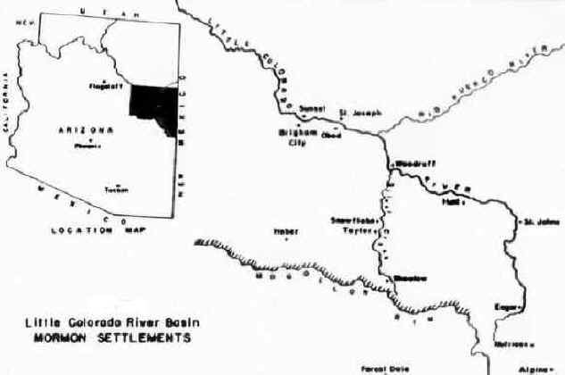
Mormon colonization of the Little Colorado River Basin began in 1873 when a well-equipped company of over 100 men, women and children was sent to the region by Church leaders in Salt Lake City (Tanner and Richards 1977:12). This initial effort failed, however, and a second attempt was made in 1876. This time, 500 pioneers were organized into four companies to maximize the success of the mission, and four settlements--Sunset, Brigham City, Obed and St. Joseph--were established along the lower valley of the Little Colorado River (see Figure 1). These settlements quickly served as bases for the founding of additional colonies throughout the river basin, including Woodruff, Snowflake, Taylor and Showlow along Silver Creek, and St. Johns, Eagar and Alpine along the upper reaches of the Little Colorado River. While most Little Colorado Mormon towns had been founded by 1880, immigration continued throughout the nineteenth century. A continuous supply of manpower was needed to secure smaller outlying valleys and to reinforce existing settlements. Because colonization proved difficult and emigration remained high, Church leaders were repeatedly forced to dispatch new settlers to the region in order to replace those who left.
Figure 1
Although political conflict with non-Mormon interests provided a significant drain on local Mormon resources during the early years of colonization (see Peterson 1973:217-41; Abruzzi 1993a:175-180), the greatest enduring hardship was imposed by vagaries of the natural environment. Crop losses from droughts and floods were a common occurrence, with additional damage inflicted by insects, hailstorms, high winds, and early frosts. So variable were local environmental conditions that individual settlements frequently lost crops to several causes during a single year (cf. Abruzzi 1993a:23-25). Consequently, agricultural productivity remained limited and highly variable throughout the settlement period. While farmers at Sunset produced nearly 7,000 bushels of wheat and corn in 1879 (Peterson 1973:19), that year's harvest exceeded the total crop raised there during the previous three years combined. Sunset was eventually abandoned in 1883 following several years of poor harvests. Brigham City also suffered repeated crop failures prior to its dissolution in 1881, while St. Joseph experienced near-total crop failure during three of the seven years between 1876-1882.
Agricultural productivity was equally variable throughout the remaining years of the nineteenth century. More than half the years between 1880 and 1900 witnessed either poor harvests or general crop failures throughout the basin, while two devastating droughts caused the additional loss of thousands of head of cattle during the 1890's (see Abruzzi 1994). So variable was agricultural productivity and so high was the cost of maintaining agricultural settlements in this climatically unstable region that many more towns would have disappeared had it not been for the judicious application of Church resources and for the strategic availability of non-agricultural employment.1 Although some settlements depended upon such subsidies more than others, no town was completely independent of extra-regional resources for its survival.
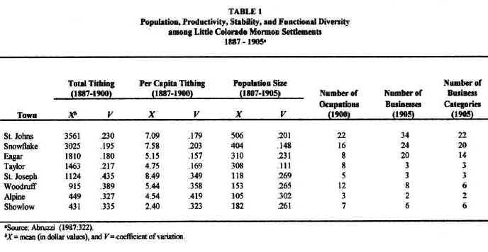
Due to their limited and variable agricultural productivity, most Mormon settlements remained economically marginal throughout the nineteenth century. However, as already indicated, significant local developmental differences occurred. Tithing records show that annual agricultural productivity varied substantially among individual settlements and within the same settlement during different years (see Table 1).2 Agricultural productivity at Snowflake and St. Johns as represented by the mean annual tithing collected at each of these towns was six times greater and only half as variable as that at either Showlow or Alpine. Tithing by field crops, a particularly revealing index of agricultural productivity, shows even greater local differences (see Abruzzi 1993a:38). Population size and stability varied substantially among these settlements as well.
In terms of agricultural productivity, four towns --Snowflake, St. Johns, Taylor and Eagar-- were the most productive and least variable Mormon settlements in the region. They also contained the largest and most stable populations and achieved the greatest occupational and business diversity. Two of these four towns--Snowflake and St. Johns--ranked highest overall. By 1900, they were the most productive agricultural communities in the entire basin and had evolved a greater occupational and business diversity than any other Mormon settlements in the region. They had also developed the most complex Church organizations and had achieved their respective organizations within the shortest period of time (see Abruzzi 1993a:43).3
In order to understand the differences
in community development that occurred during Mormon colonization of
this region, as well as the role that tithing re-distribution played in
that colonization effort, it is necessary to examine the conditions to
which these early pioneers had to adapt.
Inasmuch as the physical environment imposed the greatest
enduring stress on these towns, it is necessary to understand the nature
of that environment, in particular its spatial and temporal variation.
The Little Colorado River
Basin
The Little Colorado River Basin forms an undulating plain sloping to the north and northeast. Elevation rises from 5,000 feet near St. Joseph to about 8,500 feet along the Mogollon Rim, a steep escarpment 75 miles to the south. The southeastern portion of the basin contains several peaks exceeding 10,000 feet, including Mount Baldy, the second highest peak in Arizona, which reaches an elevation of 11,403 feet.
Climate throughout the region is arid to semi-arid, with annual precipitation ranging from 9 inches near St. Joseph to over 25 inches in parts of the southern highlands. Precipitation occurs primarily from December through March and from July through September, with little or no moisture received at most locations during the remaining months. Winter precipitation is of greater importance for local agriculture, because it is released gradually as runoff, and because it is more evenly distributed geographically. In contrast, summer precipitation occurs mostly as torrential storms which deposit large amounts of water for brief periods of time within highly restricted areas. Most summer precipitation surges down well-worn arroyos and is not available to local farmers. Furthermore, because of their intensity, summer storms are highly erosive; they remove large amounts of soil particles and increase the sediment load in streams at lower elevations.
In contrast to precipitation, length of the growing season varies inversely with elevation. The mean number of frost-free days ranges from 87 at Alpine to 179 near St. Joseph, and growing season variability increases as the mean decreases. Consequently, both the length and reliability of the growing season vary inversely in relation to average annual precipitation. This inverse relationship has made dry farming a marginal adaptive strategy locally (see Harrell and Eckel 1939:32) and has effectively limited successful agricultural settlements to river valleys below 6,000 feet where adequate growing seasons exist and where suitable surface water sources could be exploited.
The direct relationship between elevation and precipitation is reflected in a more or less clear plant community gradient throughout the region. Northern desert vegetation predominates in the lower valley of the Little Colorado River near St. Joseph and is succeeded southwards at increasingly higher elevations by grassland, juniper-piñon woodland and montane forest communities. Grasslands constitute the largest single vegetative community, comprising 40% of the total land area, followed by juniper-piñon woodland at 38% (Abruzzi 1993a:88). Bare soil accounts for 55-65% of total surface cover in the grassland community (Dames and Moore 1973 [section 4]:201), a condition which contributes significantly to the high sediment content of streams at lower elevations.
Due to increasing moisture at higher
elevations, tree size and density increase southward within the juniper
piñon woodland community, and both juniper and piñon are replaced by
forests of ponderosa pine at 6,000 feet.
Ponderosa pine is, in turn, succeeded by aspen and Englemann
spruce at 8,000 feet, while lush alpine meadows occur widely throughout
the basin above 9,000 feet.
Sub-Regions in the Basin
Based largely on climate and
precipitation, the Little Colorado River Basin may be divided from north
to south into three broad sub-regions:
(1)
the lower valley of the Little Colorado River,
(2)
intermediate elevations, and
(3) the southern highlands.
Locations within the lower valley receive about 9 inches of
annual precipitation and have an average growing season of about 180
days. St. Joseph and
Woodruff are both situated within the lower valley.
St. Joseph is located within the northern desert plant community,
while Woodruff is situated within a small valley along the northern
margin of the grassland community.
The growing season at intermediate elevations ranges from 130 to 160 days, with precipitation averaging between 12 and 13 inches. Mormon settlements at intermediate elevations include Snowflake, St. Johns, Taylor and Eagar. Snowflake and Taylor are located in adjoining valleys within the juniper-piñon woodland community, while St. Johns is situated within the grassland community. Eagar is located in a valley at the foothills of the southern mountains where the ascending vegetation succeeds rapidly from grassland through woodland to montane forest communities. While Eagar's elevation is higher than that of all other intermediate settlements, it is climatically in the shadow of nearby mountains. Consequently, Eagar experiences climatic conditions similar to those of settlements at intermediate elevations.
Alpine and Showlow are both located in the southern highlands and are situated within the montane forest community. Precipitation averages 18 inches at Showlow and about 25 inches at Alpine, the highest settlement. While the growing season at Showlow averages about 120 days, as previously indicated it is only 87 days at Alpine.
Soils. Although soils through-out the basin are generally thin and loamy, local soil characteristics and quality vary sharply (see Kester, et.al. 1964; Miller and Larsen 1975). Soils in the lower valley, particularly at St. Joseph, are generally of low fertility, being low in organic matter and deficient in both nitrogen and phosphorus. Soils in this sub-region possess low permeability and are, therefore, highly susceptible to flooding, especially during the heavy summer rains. They are also relatively high in sodium, a problem that has been seriously aggravated by irrigation (see Abruzzi 1985).
Soils at intermediate elevations are superior to those in the lower valley, with Snowflake and Taylor possessing among the best soils in the entire basin (see Kester, et.al. 1964:11). Soil permeability is moderate among all intermediate settlements except Eagar, where a temporary water table occurs in some irrigated areas during the growing season. Alkalinity is moderate in the soils at St. Johns and Eagar, while soils at Snowflake and Taylor are generally free from harmful accumulations of soluble salts, even after a century of continuous irrigation (Bureau of Reclamation 1947:42; Salt River Project 1974 [section 3]:78).
Due to the greater precipitation and denser vegetation which prevails at higher elevations, soils in the southern highlands resemble those in the north-eastern United States more than they do neighboring soils at lower elevations. Of particular significance is their high organic content and water-holding capacity. Unlike the soils near Showlow, however, those at Alpine are poorly drained and susceptible to flooding. They are also slightly acidic.
Water. The single most important physical factor influencing community development in this arid river basin has been the availability of suitable water for irrigation (see Abruzzi 1985). Early settlements had access to water in only two forms: precipitation and surface flow. As already indicated, precipitation is highly variable, inversely related to length of the growing season, and generally inadequate to support farming. The regional precipitation cycle is also incompatible with local agricultural requirements. As much as 45% of annual irrigation needs must be applied to fields during the dry months of April, May and June when there is generally little or no rain (see Bureau of Reclamation 1947:72; U.S. Geological Survey 1975:40-43).
The vagaries of precipitation made all early farming settlements in the region necessarily dependent on surface water for irrigation. However, since streams throughout the region flow largely in direct response to precipitation, surface water availability follows an annual cycle closely linked to that of precipitation (see Figure 2). Runoff is generally moderate between January and March due to the melting of snowpacks at higher elevations. As snowpacks disappear, runoff declines, and by June most streambeds in the region are dry, save those at higher elevations. With the onset of intense summer storms in July, streamflow volume and velocity increase sharply. As the summer storms pass, surface flow subsides until snow re-accumulates at higher elevations.
|
Pronounced short-term fluctuations in surface flow also occur, and it is not uncommon for dry streambeds to be transformed within hours into dangerously swollen rivers destroying all man-made obstacles in their path. This is particularly true of the Little Colorado River at lower elevations, where flooding remains a serious problem for towns situated along its route. For early Mormon settlements, the risk of flooding was especially high during spring runoff and following intense summer storms (see Abruzzi 1993a:121-142).
|
|
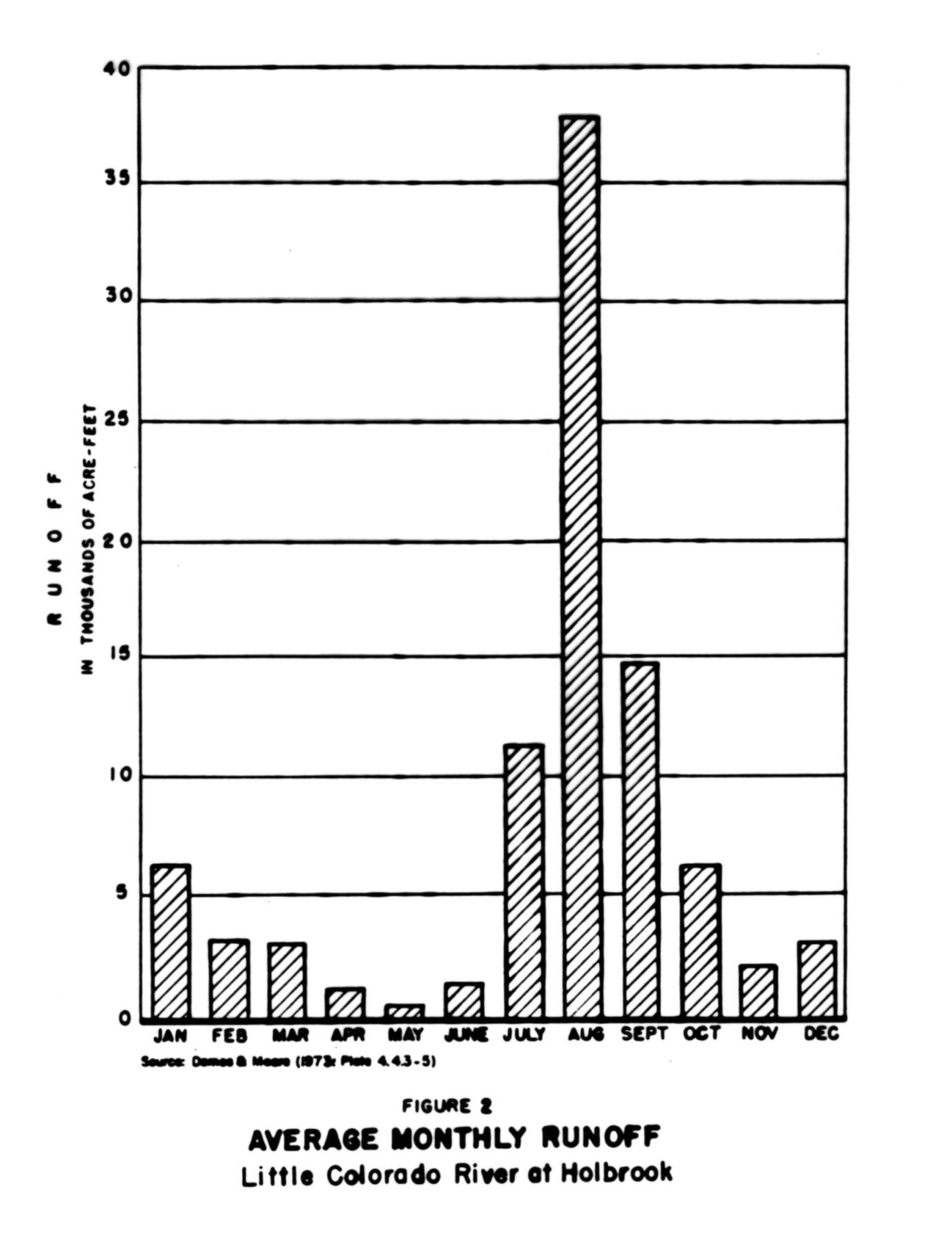
Streamflow variability also yielded a significantly higher incidence of flooding and dam failures among the lower valley settlements. St. Joseph and Woodruff suffered 13 and 10 dam failures respectively between 1876 and 1900, compared with two at St. Johns, three at Snowflake and Taylor, one at Showlow, and none at Eagar and Alpine. The greater vulnerability of irrigation systems in the lower valley was due to the inherent weakness of dams in this sub-region. Owing to the deep alluvial composition of the lower Little Colorado River bed, lower valley settlements were unable to build their dams upon firm foundations (see Abruzzi 1993a: 123-131). In addition, when sharp increases in streamflow caused the collapse of dams at higher elevations, chain reactions generally resulted in dam failures downstream as well.
The direct costs imposed by flooding and dam failures included not only the time, materials and manpower required to rebuild the dams themselves, but also those needed to repair ditches and replant fields. The indirect costs of dam failures included the labor which could not be invested in other productive activities, as well as the deleterious effect that repeated flooding had upon soil fertility. The fact that only two of the six towns established in the lower valley survived strongly suggests that the cost of farming was highest in this sub-region of the basin. No other portion of the basin lost as many settlements. Furthermore, the history of dam failures at St. Joseph and Woodruff clearly demonstrates that these two settlements would likely have become extinct as well had it not been for the repeated subsidies of cash, materials, produce and labor they received from other Mormon towns within and outside the basin (see Abruzzi 1989, 1993a:123-131).
Streamflow variability added a further burden to farming in the lower valley. Because settlements in this sub-region had to rely upon surface water as it became available, which was primarily during periods of greatest flow, they had to use this water precisely when it contained the highest sediment concentrations. Without reservoirs, farmers in the lower valley could not store surface water and allow its sediment to subside. Because the sediment load in streams at lower elevations approaches 20% of stream flow (Bureau of Reclamation 1950:3), continued irrigation there caused a decline in agricultural productivity by reducing soil aeration and permeability.
Only two streams of consequence exist in the region: The Little Colorado River and its principal tributary, Silver Creek. Most agricultural settlements were located along these two streams, whose specific characteristics contributed significantly to local differences in agricultural productivity during the settlement period. The Little Colorado River originates as snowmelt from Mount Baldy and descends quickly in a narrow stream bed. It is perennial south of St. Johns due to seeps from underground springs. How-ever, below St. Johns, the river opens into a flat, sandy bed and the gradient declines to only 10 feet per mile (Harrell and Eckel 1939:29). Surface flow is intermittent below St. Johns and is confined exclusively to subsurface channels during late spring and early summer. Water quality in the Little Colorado deteriorates rapidly downstream from St. Johns as the river flows through salt-bearing formations and receives increasing amounts of water from tributaries originating in these strata. As the Little Colorado flows through the lower valley, concentrations of sodium and other solids accumulate steadily and render its water increasingly unacceptable for domestic, agricultural or industrial use (see Abruzzi 1985, 1993a:101-103).
Silver Creek contrasts sharply with the
Little Colorado River. Originating
from a series of springs known collectively as Silver Creek Spring about
ten miles southeast of Snowflake and Taylor, it is the only fully
perennial stream in the entire river basin.
The most significant feature of Silver Creek Spring is the
abundance, reliability and quality of the water it discharges.
Several documents reveal that this spring has never failed to
flow, not even during the most protracted drought in the region (see
Harrell and Eckel 1939:30; Bureau of Reclamation 1947:50).
In addition, as already indicated, the quality of water in Silver
Creek near Snow-flake and Taylor exceeds that of all other water sources
in the basin, save those at the highest elevations.
However, as with the Little Colorado, water quality in Silver
Creek deteriorates at lower elevations, and stream-flow variability
increases.
Human Impact. Human re-source exploitation in the Little Colorado River Basin exacerbated local environmental differences. The two most prominent factors that intensified local differences in agricultural productivity were overgrazing and irrigation, both of which affected the availability of suitable quality irrigation water. The effects of overgrazing and irrigation were felt shortly after settlement had begun, and both appreciably increased the relative stress imposed upon lower valley settlements.
Overgrazing began in the 1880's when the Aztec Land and Cattle Company, a consortium of Texas ranchers and eastern businessmen, imported over 40,000 cattle into the basin (see Kennedy 1968; Abruzzi 1993a:171-175, 1994). Overgrazing resulted in a sharp decline in vegetation throughout the grassland community which, in turn, increased soil erosion and the sediment content of streams at lower elevations. Much of this sediment accumulated behind the dams and upon the fields established by the lower valley settlements. While the most destructive consequences of overgrazing followed the devastating droughts of the 1890's, negative results appeared shortly after the Aztec Company arrived in the region (see Abruzzi 1994).
Irrigation also increased the cost of
agriculture in the lower valley. As
already indicated, the continuous application of silt-laden water
exacerbated the inherent low productivity of the poorly drained,
alkaline soils of this sub-region.
Besides producing a layer of fine silt which reduced soil
permeability and aeration, irrigation also raised to the surface sodium
particles located deep within the soil structure.
Furthermore, as the settlements founded upstream from Woodruff
and St. Joseph grew and diverted larger amounts of water from the Little
Colorado River and Silver Creek, farmers in the lower valley were left
dependent upon a river which became increasingly com-posed of water
discharged by the Rio Puerco and other more northern tributaries. This
northern water is of substantially lower quality than that originating
to the south (see Abruzzi 1985, 1993a:99).
Thus, while storage reservoirs constructed at Snow-flake, Taylor,
St. Johns and other settlements upstream enabled these towns to diminish
the impact that stream-flow variability had on their agricultural
productivity, these same reservoirs reduced the quantity, stability and
quality of irrigation water available to farmers in the lower valley.
The Physical Environment and Community Development
In summarizing the role that the physical environment played in local community development, it may be stated that individual settlements evolved complex community organizations to the degree to which they were able to overcome critical limiting factors in their local environments. Settlements at the highest elevations were severely con-strained by a growing season which was generally too short and too variable to allow consistently adequate harvests. Because an inadequate growing season imposed a limiting factor beyond effective human control, towns at the highest elevations remained the smallest, least productive and least complex of all Mormon settlements in the region.
While lower valley settlements did not have to contend with inadequate growing seasons, they consistently endured high summer temperatures, dust storms and an annual spring dry season which limited agricultural productivity throughout this subregion. In addition, they had to irrigate relatively infertile soils with the poorest quality, least reliable surface water in the entire region. Lacking suitable reservoir sites, lower valley settlements were also unable to overcome the increasing instability and decreasing quality of their water supply caused by activities upstream. The growth of these towns was further limited by recurring dam failures. Each dam failure produced a decline in population which, in turn, under-mined the maintenance and repair of irrigation systems and the planting and care of crops. Thus, while the lower valley settlements achieved a higher average annual agricultural productivity than those in the southern highlands, their greater productivity was largely offset by its variability and by the substantial costs required to achieve it.
In contrast to all other settlements in
the basin, those at intermediate elevations suffered neither inadequate
growing seasons nor unreliable water supplies.
All four towns at intermediate elevations enjoyed an average
growing season in excess of 120 days, while proximity to perennial
streams and suitable reservoir sites spared these towns the degree of
surface water variability that plagued settlements in the lower valley.
The four inter-mediate settlements were also situated in the
largest and most fertile valleys and were able to irrigate those valleys
with relatively abundant, reliable and silt-free water.
While not without problems, irrigation systems at intermediate
settlements suffered significantly less destruction than those at lower
elevations. Furthermore,
when damage to irrigation systems did occur, these settlements contained
the largest populations among which to distribute the costs of repair.
Released from having to expend excessive amounts of time and
energy just to maintain their infrastructure and their existing levels
of productivity, farmers at intermediate settlements could channel
surplus resources into those activities which improved and expanded
irrigation systems, increased agricultural production and promoted
population growth. Together,
these activities provided the material basis from which more complex
communities evolved. Of all
the Mormon towns in the basin, it was primarily the intermediate
settlements. in particular Snowflake and St. Johns, that most closely
approached the 19th century Mormon ideal of stable, diversified
agricultural villages independent of surrounding non-Mormon communities
and containing the full complement of Church institutions.
Tithing Redistribution
Local environmental variability clearly imposed a considerable stress on these early pioneers. It resulted in highly variable harvests, frequent crop failures and devastating dam losses. Indeed, the consequences of this variability caused the extinction of four out of the six settlements established in the lower valley and repeatedly threatened the entire colonization effort. However, through the collection, storage and redistribution of tithing resources, the Little Colorado Mormon settlements were able to substantially offset the negative consequences of local environ-mental variability. As a result of tithing redistribution, individual towns facing a crop failure and/or a dam loss could acquire the resources they needed to survive until the following year's harvest.
The effectiveness of tithing redistribution was based in large part on the fact that it used the region's spatial diversity to offset its temporal variability. The various Mormon towns were situated in widely scattered river valleys which generally experienced distinct schedules of variability. Thus, due to local differences in elevation, precipitation, temperature, growing season, soil quality and surface water availability, droughts, floods and other catastrophes occurred at diverse locations during various years. As a result, no clear correlation existed in the annual pattern of agricultural productivity achieved among the various towns in the region (see Lightfoot 1980:206-208).
For example, when warm years occurred throughout the region, they generally increased the length of the growing season at higher elevations and raised the probability of a successful harvest at towns such as Showlow and Alpine. However, these same higher temperatures increased the likelihood of crop failures at St. Joseph, Woodruff and other towns through the heat stress and higher evapotranspiration rates they imposed on crops at lower elevations. Similarly, while cooler temperatures reduced heat stress on crops at lower elevations and raised the prospects of a good harvest in the lower valley, they increased the likelihood of destructive early frosts in the southern highlands. Likewise, while abundant rainfall generally increased agricultural productivity at lower elevations where permanent surface water sources were unavailable, it also resulted in flooding and crop damage at higher elevations, where soil permeability is low, and increased the risk of dam washouts along the lower valley of the Little Colorado River where the alluvial streambed inhibited the construction of dams able to withstand sharp increases in streamflow. In 1890, for example, most towns within the region experienced increased harvests due to an unusually wet agricultural season. However, during that same year crops rotted in the fields at Alpine and dams washed out at Snowflake, Taylor, Woodruff and St. Joseph as a result of the flooding that occurred.
Significantly, tithing redistribution was not the only system of resource redistribution developed by the Little Colorado Mormon pioneers. Previously, the lower valley settlements jointly operated a series of productive enterprises in the southern highlands, including a sawmill, a dairy, a grist mill and a tannery. These enterprises provided the lower valley settlements with cheese, butter, meat, lumber and other products which could not be produced locally and which supplemented the wheat, corn, barley, sorghum and garden vegetables which they raised by irrigated farming along the Little Colorado (see Abruzzi 1989). However, while these conjoint enterprises prospered initially, they all eventually failed and, unlike tithing redistribution, never served as an effective system of resource redistribution counter-acting local environmental variability.
The failure of the conjoint enterprises was primarily due to the fact that they were supplementary operations which were ultimately dependent upon prevailing environmental conditions in the lower valley. Since all four enterprises were primarily summer operations, they necessarily competed for labor with farming in the lower valley. They, therefore, could only be developed to the extent that surplus labor was available among the lower valley towns during this time of the year. However, the lower valley settlements were all situated at neighboring locations within the same subregion and experienced nearly identical schedules of environmental variation. Most importantly, they generally experienced simultaneous dam failures and the intense demand for labor that subsequent dam reconstructions imposed. Thus, as St. Joseph, Woodruff and the other lower valley towns continuously struggled with floods, poor harvests and recurring dam failures, their populations dwindled and their ability to provide the additional manpower needed to operate the various conjoint enterprises declined. With the dissolution of Sunset, Brigham City and Obed and the decline of population throughout the lower valley, the conjoint operations could no longer be maintained and were eventually abandoned.
The system of tithing redistribution, thus, succeeded for the very reasons the conjoint enterprises failed. First, tithing redistribution included every town in the basin and was, therefore, not limited by the environmental conditions which prevailed in just one portion of the basin. Furthermore, the productivity upon which tithing redistribution depended was based on the total labor of over 2,000 individuals inhabiting some two dozen separate communities situated in numerous, diverse and functionally independent local environments which were influenced by quite different schedules of variability. The conjoint enterprises, on the other hand, depended on the surplus labor of some 200 persons inhabiting a handful of towns in nearly identical neighboring environments experiencing nearly identical schedules of variability in the most unstable portion of the basin. Finally, unlike the conjoint enterprises, the relative effectiveness of tithing redistribution was enhanced by the fact that: (1) it operated through a centrally administered religious organization that encompassed every town in the region; and (2) the local institutions through which it operated were affiliated with encompassing parent organizations outside the region which were independent of local environmental conditions (see Abruzzi 1989).
It has thus far been shown that local
differences in community development among pioneer Mormon settlements in
the Little Colorado River Basin were largely consequences of divergent
environ-mental conditions. It
has also been shown that tithing redistribution:
(1)
was critical to the success of this colonization effort because it
effectively offset the destabilizing consequences of local environmental
variability for community development; and
(2)
was more effective in counteracting environmental variation than the
previous system of conjoint enterprises because it linked some two dozen
communities located in diverse habitats widely scattered throughout the
basin and was not limited, as was the system of conjoint enterprises, to
the surplus productivity of a few towns which were situated in
neighboring locations within a single highly variable subregion.
However, it still remains to be seen that all of these
developments can be explained by general ecological theory.
The Evolution of Ecological
Communities
Ecological communities, be they single or multi-species communities, evolve to the extent that the individual organisms and populations within them are able to exploit an increasingly narrow range of resources and, thus, occupy more specialized niches. Since competition promotes adaptive specialization and niche differentiation (see Levins 1968:10-38; Vandermeer 1972: 114-116), natural selection produces the greatest functional diversity possible within a community.4 Community evolution, thus, represents an incessant developmental process climaxing in the most diverse community structure that can be supported by available resources. Consequently, in order to explain the evolution of complex ecological communities, it is necessary to understand those factors which enhance or constrain adaptive specialization and niche differentiation within ecological systems.
Maintenance costs pose the principal constraint upon specialization and community evolution. Ecological communities exist because abundant supplies of potential energy occur in their environments, and their complexity increases to the extent that this potential energy is converted into community productivity, biomass (population) and functional diversity. However, those activities which are needed to maintain organisms and populations within a community consume energy and are lost to the system. That is, they cause energy to flow out of the community rather than through it. For example, the cost of maintaining organisms at one trophic level within multi-species communities reduces the amount of net productivity that can be transferred to all subsequent trophic levels. Maintenance costs, thus, limit both the number and the diversity of species that can be maintained within a community. A decrease in maintenance costs increases community diversity by increasing the net productivity of a community, or the total amount of energy that flows through the community. As net productivity increases, the adaptive advantage of specialization increases, which leads to greater community diversity. An increase in maintenance costs has just the opposite effect. As maintenance costs increase, the total flow of energy through a community declines. As a result, the adaptive advantage of specialization is reduced, and community diversity decreases.
Complex ecological communities evolve,
then, as a result of the selective advantage gained by organisms
exploiting an increasingly narrow range of resource and from the
interdependent network of energy flows that such increasing
specialization creates (see E. Odum 1971:37-85; H. Odum 1971:58-103;
Whittaker 1975). The conditions which enhance community diversity are,
therefore, those which increase the amount and reliability of energy
flowing through the community and which reduce community maintenance
costs. All external factors
which influence the flow of energy through ecological communities may,
therefore, be classified according to the effect they have upon
maintenance costs and community evolution.
Those factors which reduce maintenance costs and increase
community diversity are defined as
energy
subsidies, while those
which increase maintenance costs and reduce community diversity are
classified as
energy
drains (see E. Odum
1971:43-53; Abruzzi 1993:58-59, 68).
Al-though numerous specific environmental conditions act as
either subsidies to or drains upon community evolution, research has
shown that certain general considerations prevail.
The
most complex ecological communities evolve in environments that are both
productive and stable (cf.
MacArthur and MacArthur 1961; Pianka 1966; Margalef 1968; Rosenzweig
1968; Sanders 1968; Slobodkin and Sanders 1969; May 1973; Whittaker
1975; Cody and Diamond 1975; Abruzzi 1987, 1993:55-78).
Environmental productivity is positively associated with community diversity, because greater productivity increases the likelihood that resources which might otherwise be insufficient to support a particular adaptive specialization will be sufficient for its maintenance. Conversely, those factors which decrease productivity reduce the adaptive advantage of specialization. As a result, organisms which inhabit unproductive environments must generally exploit a broader range of resources than those in more productive ecosystems (cf. Terborgh 1971).
However, while environmental productivity has traditionally been considered the a priori condition needed for the evolution of complex ecological communities, research has demonstrated that the developmental benefits of high productivity can be compromised and even negated by environmental instability (see Sanders 1968; Holling 1973; May 1973; Leigh 1976). Since a high degree of adaptive specialization can only evolve where the availability of required resources is reliable, the same selective factors which limit functional diversification in unproductive environments restrict its development in unstable ones as well. Consequently, complex eco-logical communities evolve only in highly predictable environments with low variability. The greater diversity of tropical multispecies communities, for example, derives less from abundant productivity than from environmental stability (cf. Sanders 1968).
For several years, ecologists have debated the precise relationship between diversity and stability in ecological systems. While the thesis outlined above that stability enhances diversity in ecological communities has received widespread empirical support (cf. Sanders 1968; May 1973; Pielou 1975; Cody and Diamond 1976), considerable re-search also exists which supports the alternate thesis that complexity promotes stability (cf. McArthur 1955; McArthur and Connell 1966; Margalef 1968; Brookhaven National Laboratory 1969; Rogers and Hubbard 1974). The controversy surrounding the causal priority of diversity versus stability in ecological communities likely reflects processes operating at distinct levels in hierarchically organized ecological systems (see Leigh 1977; Alexander and Borgia 1978; Abruzzi 1982:28-31; Ricklefs 1987). The enhanced community stability that results from community diversity derives ultimately from the productivity and stability of the encompassing ecosystems within which ecological communities exist (see Abruzzi 1987).
However, functional diversity promotes stability in ecological communities under very specific conditions based on the degree to which redundancy exists in the flow of energy/resources through a community. Sufficient redundancy can only exist when the various energy/resource flows of a community originate in numerous functionally independent channels. Only then can the destabilizing effects of environmental perturbations be offset by a complex network of overlapping energy/resource flows. Where sufficient redundancy does not exist, the negative con-sequences of environmental variability are more likely to ramify throughout a community and reduce its stability, even within relatively diverse communities (May 1973; Holling 1973; Leigh 1976; Abruzzi 1993a:62-64).
If the above ecological considerations
are to prove applicable to the Little Colorado Mormon settlements, then
the most functionally diverse of these towns should have evolved in the
most productive and stable environments and should have been
characterized by the largest and most stable populations and
agricultural productivities. Conversely,
the least diverse communities should have been situated in the least
productive and stable environments and should have been characterized by
small, unstable populations and by limited and variable agricultural
productivities. Furthermore,
the contribution of tithing redistribution to the colonization effort
should have derived from the fact that it provided sufficient redundancy
in the flow of resources to offset the impact of local environmental
variability on community survival. Moreover, the degree of redundancy provided by tithing
redistribution in the flow of energy/resources among local communities
should have substantially exceeded that provided by the unsuccessful
system of conjoint enterprises. A
brief reconsideration of the material presented above will show that the
developments which occurred during Mormon colonization in the Little
Colorado River Basin conform to ecological expectations.
Ecological Theory and the Little Colorado Mormon
Communities
Mountain valley settlements were located within small, narrow valleys at elevations which offered generally inadequate and highly variable growing seasons. Low environmental productivity and stability prevailed under such conditions and resulted in both limited and highly variable community productivity among settlements in this subregion. As predicted by ecological theory, mountain valley settlements were the smallest and least functionally diverse communities in the region. Additional problems existed at Alpine, due to its higher elevation, which made it the least diverse even of the mountain communities (see Abruzzi 1993a:119).
St. Joseph and Woodruff are situated within larger valleys than either Alpine or Showlow, offering them the potential for greater aggregate community productivity. However, poor soils, high evapotranspiration and inferior quality irrigation water limited the natural productivity of these valleys. In addition, sharp fluctuations in the water supply restricted each community's productivity and contributed to its substantial variability. Climatic instability also caused frequent dam losses which imposed high maintenance costs upon these two settlements and exacerbated their highly variable populations and agricultural productivities. St. Joseph, Woodruff and the other lower valley settlements also endured the greatest negative consequences of human environmental activities elsewhere in the basin, which consistently reduced the already low environmental productivity and stability of this sub-region. Although lower valley settlements achieved slightly higher levels of community productivity than did those at the highest elevations, the positive developmental effect of these higher levels was negated by both intense environmental instability and oppressive maintenance costs. Consequently, this subregion witnessed the greatest number of failed settlements, and the functional diversity attained at St. Joseph and Woodruff by the close of the nineteenth century was not substantially greater than that achieved by the mountain valley settlements.
As already indicated, all of the most successful settlements in the region were situated at intermediate elevations. In each instance, large valleys, sufficient growing seasons, good soils and abundant, superior quality irrigation water yielded high environmental productivity. Environmental stability resulted from perennial surface water sources, and was enhanced through the construction of storage reservoirs. Maintenance costs were also the lowest in the region. With high environmental productivity and stability yielding large populations subject to relatively low maintenance costs, intermediate settlements generated the highest and most stable levels of net productivity of any settlements in the region. As predicted by ecological theory, they also achieved the greatest functional diversity.
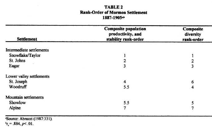
The same ecological considerations used to explain sub-regional variations in community development may also be applied to account for individual differences in community development as well. Table 2 ranks and compares individual settlements according to composite indices of population, productivity and stability on the one hand and functional diversity on the other. In the first column, each settlement's composite population-productivity-stability ranking is achieved by averaging its separate individual rankings for mean (X) and coefficient of variation (V) of annual tithing and population size. Column two presents each settlement's composite functional diversity ranking by averaging its individual ranking for number of occupations, businesses and business categories. Snow-flake and Taylor are treated as a single community in the calculations performed.5 As predicted by ecological theory, a strong positive rank-order correlation is achieved.
Finally, ecological theory accounts for
the role that tithing redistribution played in successful colonization.
Through tithing redistribution, local Church leaders were able to
channel considerable resources into local projects which enhanced
community productivity and stability and which, therefore, advanced the
colonization effort. Since
the system of tithing redistribution encompassed every town, it
integrated the productivity and labor originating in every occupied
habitat throughout the region. Redundancy
clearly existed in this system of resource redistribution, as it was
based on the exploitation of diverse habitats by permanent and
independent populations which were not simultaneously affected by the
same environmental perturbations. It,
therefore, contained numerous, overlapping resource flows which
originated from independent sources whose productivities displayed
distinct schedules of variation. In
addition, this system's link with comparable systems outside the basin
augmented its inherent redundancy by connecting it to resource flows
which were completely independent of environmental conditions within the
basin. From the perspective
of ecological theory, tithing redistribution stood in sharp contrast to
the earlier system of conjoint enterprises.
The latter system contained little redundancy because it was
ultimately dependent upon environmental conditions which prevailed
within the highly variable lower valley.
Consequently, whereas tithing redistribution effectively offset
the destabilizing consequences of local environmental instability, the
system of conjoint enterprises succumbed to it.
CONCLUSION
The above discussion of Mormon
colonization in the Little Colorado River Basin has shown that physical
environmental differences underlay variations in community development
in the region. The dominant
role of the natural environment is strongly suggested both by the
similar pattern of development displayed by settlements in the same
sub-region and by the regional pre-eminence achieved exclusively by
towns located at intermediate elevations.
More importantly, however, the present investigation shows that
local differences in community development can be systematically
explained through the application of general ecological theory.
Specifically, ecological theory explains:
(1)
individual differences in community development, (2)
sub-regional variation in community development,
(3)
the greater complexity of intermediate settlements,
(4)
the regional pre-eminence of Snowflake and St. Johns, (5)
the contribution of tithing redistribution to successful colonization,
and (6)
the greater success of tithing redistribution compared to the conjoint
enterprises as a mechanism for counteracting the negative consequences
of environ-mental variability.
Ecological theory, therefore, provides
a precise and parsimonious explanation of Mormon colonization in the
Little Colorado River Basin that concurs with explanations for the
evolution of non-human ecological communities.
By demonstrating that specific developments associated with
Mormon settlement in this region conform to general ecological
expectations, the present analysis suggests that it may be possible to
develop a single theoretical framework to explain the evolution of human
and non-human communities alike (see Abruzzi 1993a:55-78).
NOTES
1. Church subsidies were critical to the survival of most settlements in the region (see Abruzzi 1993a:180-181, passim). Among other things, the Church furnished material support for the rebuilding of dams; it redirected tithing revenues to offset poor harvests; it subsidized land purchases; it negotiated grading contracts with the Atlantic and Pacific Railroad to provide needed employment; and it repeatedly provided manpower through its "calls" for pioneers to settle in the basin. Externally-generated employment was also important. A railroad grading contract negotiated by the Church enabled many settlers to replace their dangerously depleted food stocks following the severe winter of 1879 and the general failure of the 1880 harvest. Freighting, particularly to Fort Apache to the south, was also of considerable economic importance to early settlements. Freighting contracts provided an important income for the Arizona Cooperative Mercantile Institution (ACMI), the Church-related mercantile establishment in the region (see Peterson 1973:136-153; Leone 1979:79-82). This institution provided temporary employment for many early settlers. It was, for example, an important source of income for settlers at Woodruff following each of several dam failures.
2. Cash was a scarce commodity in this frontier region. Consequently, nearly all tithing received in the Little Colorado Settlements during the nineteenth and early twentieth centuries was paid in kind. Items were tithed as they became available, and tithing stocks were generally most abundant during the fall, following the harvest. Tithing data, therefore, provide reliable indices of community productivity.
3. The Mormon Church is divided administratively into stakes and wards, which may be compared to diocese and parishes respectively in the Roman Catholic Church. Each of these administrative levels is composed of different organizations which perform distinct functions. During the nineteenth century, each settlement contained one ward, and by the close of the century two stakes had been established in the region, one at Snowflake and the other at St. Johns.
Differences in local church organization are important for understanding the evolution of community complexity among these early settlements. The local church organization provided the near-exclusive governmental apparatus through which the temporal affairs of these communities were administered. Local church leaders presided over such matters as land distribution, dam construction and maintenance, property disputes, distribution of tithing, and punishment for such local offenses as theft and adultury. The full complement of ward and stake organizations were not established simultaneously. Rather, specific organizations were formed as resources, most notably manpower, was available to perform their specific functions. Differences in the complexity of church organization, thus, reflect local differences in the availability of administrative resources.
4. Ecological theory regarding community evolution has been developed largely in relation to multi-species communities. Consequently, species number and variety have been used to determine the functional diversity of these communities (cf. Margalef 1968; Brookhaven National Laboratories 1969; Whittaker 1975; Cody and Diamond 1976). However, studies of functional diversity have also focused on single-species communities including, examining such topics as caste diversity among social insects (Wilson 1968) and the organizational complexity of non-human primates (cf. Kummer 1971). In the meantime, occupational categories and such functional units as farms, churches, businesses, lineages or military societies have been used in a variety of disciplines to define the functional complexity of human societies (cf. Naroll 1956; Thomas 1960; Carneiro 1962, 1967, 1968; Clark, et.al. 1964; Gibson and Reeves 1970). In each of the above situations, the analytical unit employed delineates the organization of productive functions within the respective community studied and varies in its dimensions in response to conditions of resource availability. Each can, therefore, be equally considered an Operational Taxonomic Unit (OTU) within niche theory (see Vandermeer 1972).
5.
Due to their close proximity and functional interdependence, Snow-flake
and Taylor must be considered a single community in the analysis of
community development in this region. Located in adjoining valleys less than three miles apart and
sharing Silver Creek's water, Snowflake and Taylor quickly established a
unified irrigation system. Close
proximity led to the integration of most other community functions as
well.
REFERENCES CITED
Abruzzi, W.S. 1982. Ecological Theory and Ethnic Differentiation among Hu-man Populations. Current Anthropology 23:13-35.
Abruzzi, W.S. 1985. Water and Community Development in the Little Colorado River Basin. Human Ecology 13: 241-269.
Abruzzi, W.S. 1987. Ecological Stability and Community Diversity during Mormon Colonization of the Little Colorado River Basin. Human Ecology 15:317‑338.
Abruzzi, W.S. 1989. Ecology, Resource Redistribution and Mormon Settlement in Northeastern Arizona. American Anthropologist 91:642‑655. (1989)
Abruzzi, W.S. 1993a. Dam That River! Ecology and Mormon Colonization of the Little Colorado River Basin. Landam, MD: University Press of America.
Abruzzi 1993b. Ecological Concepts in Anthropological Human Ecology: Illustrations from Mormon Settlement in Northeastern Arizona. in Scott Wright, ed., Human Ecology: Crossing Boundaries. Society for Human Ecology: College Park, MD.
Abruzzi, W.S. 1994. The Social and Ecological Consequences of Early Cattle Ranching in Northeastern Arizona. Human Ecology 23:75-98
Alexander,
R.D., and G. Borgia 1978. Group Selection, Altruism, and the Levels of
Organization of Life.
Annual Review of Ecology and Systematics 9:449-474.
Arrington,
L.J.
Brookhaven
National Laboratory. 1969.
Diversity
and Stability in Ecological Systems. Brookhaven Symposia in Biology
No. 22. Springfield: U.S.
Department of Commerce.
Bureau
of Reclamation 1947.
Snowflake Project Arizona.
Project Planning Report
3-8b.2-0.
Washington, D.C.: U.S. Department of the Interior.
Bureau
of Reclamation. 1950.
Report on Joseph City Unit, Holbrook Project, Arizona. Project
Planning Report 3-8b.6-1. Washington,
D.C.: U.S. Department of the Interior.
Carneiro,
R.L. 1962. Scale Analysis as an Instrument for the Study of Cultural
Evolution.
Southwestern Journal of
Anthropology 18:149-169.
Carneiro,
R.L. 1967. On the Relation between Size of Population and Complexity of
Social Organization.
South-western
Journal of Anthropology 23:234-243.
Carneiro,
R.L. 1968. Ascertaining, Testing and Interpreting Sequences of Cultural
Development.
Southwestern Journal
of Anthropology 24:354-374.
Clark,
P.J., P.T. Eckstrom, and L.D. Linden. 1964. On the Number of Individuals
Per Occupation in a Human Society.
Ecology
45:367-72.
Cody,
M.L., and J.M. Diamond, eds. 1975.
Ecology
and Evolution of Communities. Cambridge:
Belknap Press.
Dames
and Moore, Inc. 1973.
Environmental
Report, Cholla Power Project, Joseph City, Arizona.
Phoenix: Arizona Public Service Company.
Gibson,
L.J, and R.W. Reeves. 1970. Functional Bases of Small Towns: A Study of
Arizona Settlements.
Arizona
Review 19:19-26.
Harrell,
M.A., and E.B. Eckel. 1939
Ground-water Resources of the Holbrook Region, Arizona.
U.S. Geological Survey Water-Supply Paper 836-B.
Washington, D.C.: U.S. Government Printing Office.
Holling,
C.S. 1973 Resilience and
Stability of Ecological Systems.
Annual
Review of Ecology and Systematics 4:1-23.
Kennedy,
S. A. 1968
A General
History of the Hashknife Range under the Aztec Land and Cattle Company,
Limited. Unpublished manuscript, Arizona Collection, Arizona State
University Library.
Kester,
G., et.al. 1964
Soil
Survey: Holbrook-Showlow Area, Arizona.
U.S. Department of Agri-culture, Soil Conservation Service.
Washington, D.C.: U.S. Government Printing Office.
Leigh,
E.G. 1976 Population
Fluctuations, Community Stability, and Environmental Variability.
In
Ecology and Evolution of
Communities, M.L. Cody and L.M. Diamond, eds. Pp.51-73.
Cambridge: Belknap Press.
Leigh,
E.G. 1977. How Does Selection Reconcile Individual Advantage With the
Good of the Group?
Proceedings of
the National Academy of Sciences
74:4542-46.
Leone,
M.P. 1979.
The Roots of Modern
Mormonism. Cambridge:
Harvard University Press.
Levins,
R. 1968.
Evolution in Changing
Environments. Princeton:
Princeton University Press.
Lightfoot,
K. 1980. Mormon Sociopolitical Development in Northern Arizona,
1876-1906: Implications for a Model of Prehistoric Social Change.
Ethnohistory
27:197-223.
MacArthur,
R.H. 1955. Fluctuations in Animal Populations and a Measure of Community
Stability.
Ecology 36:533-537.
MacArthur,
R.H. and J. MacArthur. 1961. On
Bird Species Diversity.
Ecology
42:594-98.
MacArthur,
R.H., and J.H. Connell. 1966.
The
Biology of Populations.
New York: Wiley.
Margalef,
R. 1968.
Perspectives in
Ecological Theory. Chicago:
University of Chicago Press.
May,
R.M. 1973.
Stability and
Complexity in Model Eco-systems.
Princeton: Princeton University Press.
Miller,
M.L., and K. Larsen. 1975.
Soil
Survey of Apache County, Arizona: Central Part.
U.S. Department of Agriculture, Soil Conservation Service. Washington, D.C.: U.S.
Government Printing Office.
Naroll,
R. 1956. A Preliminary Index of Social Development.
American
Anthropologist 58: 687-715.
Odum,
E.P. 1971.
Fundamentals of
Ecology, Third Edition. Philadelphia:
Saunders.
Odum,
H.T. 1971.
Environment, Power, and
Society. New York: Wiley
and Sons.
Peterson,
C.S. 1973.
Take Up Your Mission:
Mormon Colonizing Along the Little Colorado River 1870-1900. Tucson:
University of Arizona Press.
Pianka,
E.R.
1966.
Latitudinal Gradients in Species Diversity: A Review of Concepts.
The American Naturalist
100:33-46.
Pielou,
E.C.
____1975.
Ecological Diversity. New
York: John Wiley and Sons.
Ricklefs,
R.E.
Rogers,
D., and S. Hubbard. 1974. How the Behavior of Parasites and Predators
Promotes Population Stability. in M.B. Usher and M.H. Williamson, eds.
Ecological Stability, pp. 99-119. London: Chapman and Hall.
Rosenzweig,
M.L. 1968. Net Primary
Productivity of Terrestrial Communities: Pre-dictions from
Climatological Data.
American Naturalist 102: 67-74.
Salt
River Project 1974.
Environmental
Report, Arizona Station Project: Snowflake and St. Johns Generating
Station
Sites. Phoenix:
Salt River Project.
Sanders,
H.L. 1968. Marine Benthic
Diversity: A Comparative Study.
The
American Naturalist 102:243-82.
Slobodkin,
L.B., and H.L. Sanders.
Stegner,
W. 1942.
Mormon Country. New
York: Hawthorne Books.
Stegner,
W. 1964.
The Gathering of Zion:
The Story of the Mormon Trail. New York: McGraw-Hill.
Tanner,
G.M., and J.M. Richards. 1977.
Colonization
on the Little Colorado: The Joseph City Region. Flagstaff, Arizona:
Northland Press.
Terborgh,
J. 1971. Distribution of
Environmental Gradients: Theory and a Preliminary Interpretation of
Distributional Patterns in the Avifauna of the Cordillera Vilcabamba,
Peru.
Ecology 52: 23-40.
Thomas,
E.N. 1960. Some Comments on the Funtional Bases for Small Iowa Towns.
Iowa Business Digest 31:10-16.
United
States Geological Survey. 1975.
Surface Water Supply of the United States, 1966-70. Part 9, Volume 3:
Lower Colorado River Basin. Water-Supply Paper 2126. Washington:
U.S. Government Printing Office.
Vandermeer,
J.H. 1972 Niche Theory.
Annual Review of Ecology and Systematics 3:107-32.
Whittaker,
R.H. 1975.
Communities and
Ecosystems, Second Edition. New
York: Macmillan.
Wilson,
E.O. 1968. The Ergonomics of
Caste in Social Insects.
American
Naturalist 102: 41-66.